Grossvenediger
Climbing one of the highest
glacier peaks in the Austrian Alps
The
highest mountain range in the Austrian Alps is in the
Towards
the end of a 2 week vacation in
Usually
it takes 2 days for the climb and you stay overnight at one of the huts built
by the Austrian Alpine Club (OEAV),
such as the ‘Kuersinger-Huette’ or the ‘Prager Huette’. Since I had very little
time, I was going to attempt it in just 1 day. From the North, the vertical
gain is about 2700m (9000 ft) as one cannot enter the valley very far by car
(due to the National Park boundaries). This makes for a very long ascent and
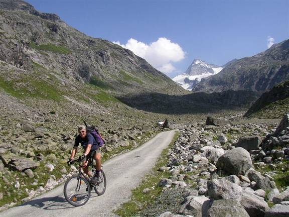
descent in a single day. At least I would be using the mountain bike – the same
MTB I used on the Grossglockner pass
ride last year - to ride along the dirt road for the first 900 vertical
meters and a considerable horizontal distance. More importantly, it would
shorten the descent, as you can just roll back down at the end of a long day of
hiking. But it will still be a very long day…
Thursday, July
28, 2005
The
alarm clock rings at 2:15am. I had loaded the MTB into my mother’s car and
prepared my backpack and all necessary gear like ice axe, crampons, warm
clothing and food the evening before. Hence I only get dressed, drink some
juice and start driving less than 15 minutes after getting up. I stop at an
Autobahn gas station to buy fresh batteries for my digital camera and a battery
light for the predawn parts of the ascent. The 145km (90 miles) approach drive
takes about 1 ¾ hours. I park the car, unload the MTB and put on my heavy
hiking boots. Here in the valley it has a crisp 13 C (56 F); but I can still
start in shorts and T-shirt, as the initially steep ascent on the bike will get
me heated up quickly. It is 4:30am when I start the ascent from the parking
spot at an elevation of just 1000m.

Riding
at night is not too bad since there is a half moon and absolutely not a single
cloud in the sky full of stars. I put the small battery light in the pocket of
my shorts. I use it only once or twice when approaching a gate in te road to
check that there are no barbed wires or bars across the road. The ride feels a
bit surreal, with nobody out there, and the same strange feeling I always have
in the predawn hours when starting a trip, when the mind is still transitioning
from anticipation to participation. The sound of the river is greatly
amplified, both by the absence of any other noises in the early morning, by the
huge water runoff due to the snow melt, as well as by the absence of daylight,
which makes your brain tune in more to other senses like smell and hearing.
After ½ hr I reach the Bernd-Alm at 1,500 m.

The
predawn sky is turning into shades of dark and light blue. No more need for the
battery light. My backpack is strapped to the back of the bike, which is more
comfortable and less sweaty for my back. The mountain peaks emerge around the
valley (‘Obersulzbach-Tal’). Next stop Post-Alm at 1,700 m.
Only
cows are up this early in the morning, or so it seems along this path. Actually
it turns out that most climbers headed for the summit today have already
departed the various huts further up the valley. By the time I reach the end of
the dirt road at 6:15am some of them are already walking on the glacier much
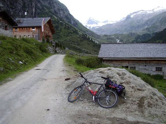
higher on the mountain. I park the MTB next to a few others at the base station
of a material lift (1,929 m) which forms the supply line up to the Kuersinger
hut. The base station is at the end of the dirt road in the middle of the next
picture. The first part of the day has gone according to plan and the weather
is brilliant. As I start hiking up the valley towards the hut I am happy and
confident.
In
the meantime the sun has risen and illuminates the mountain ranges high above
with warm yellow light, painting a spectacular contrast to the dark blue sky.
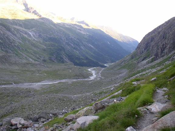
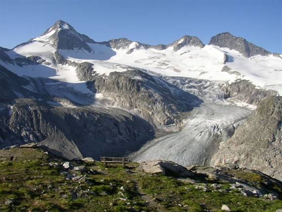
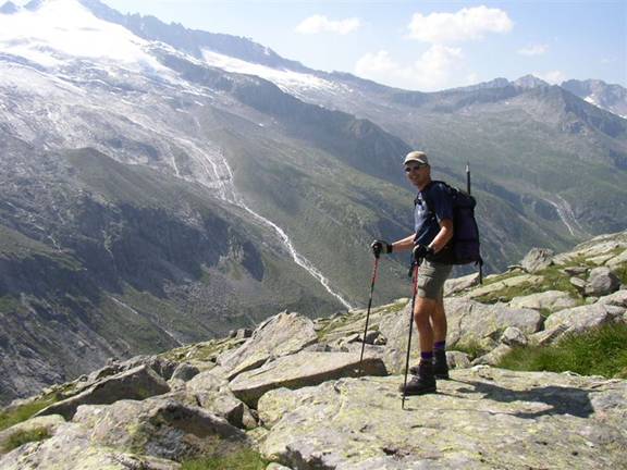
In
the Austrian Alps the tree line is at around 1,800 m. Above 2,000 m you have
only rocks and grass, as visible in the above view back down the valley. This
landscape with the “U”-shaped valley was formed primarily by the glaciers in
the 10,000 years since the last ice age. Those glaciers have also moved along
steep rock formations, which the path needs to cross climbing up to the hut.
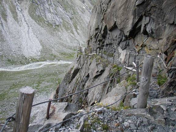
The
path poses no technical difficulty, but at times you need to pay attention
where you’re stepping and that you’re not slipping when crossing a larger
bolder. In that sense it reminds me a bit of the boulder field we had to cross
on the climb
of Granite Peak in Montana, although that one was much more remote and
challenging by comparison.
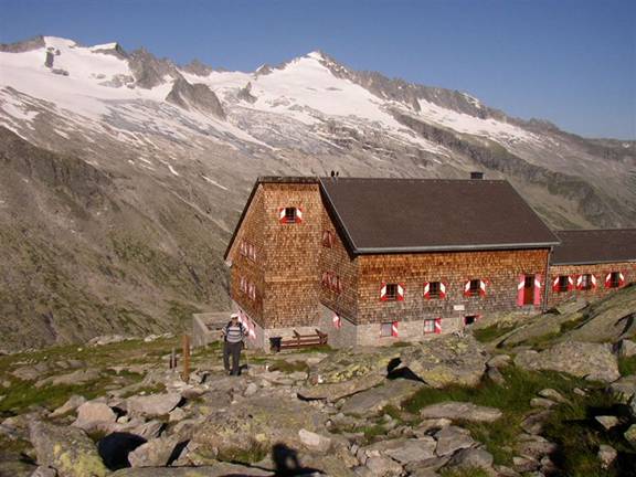
This
part of the hike is great, the air is still cool in the shade, the views are
getting ever more spectacular. After 1 ½ hrs of steady climbing I see the
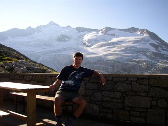
Kuersinger hut (2,550 m) and reach it shortly thereafter at 7:50am.

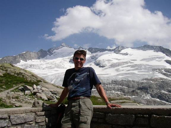
It
is here that I can see the summit of the Grossvenediger for the first time. In
contrast to the above mentioned Granite Peak trip, most alpine endeavours in
Just
to the right from this same vantage point is another picture perfect post card
view to the Grosser Geiger, which at 3,300 m dominates the view during the
approach hike in the valley. Wouldn’t you like to have breakfast with such a
view?
After
½ hour of feasting both on calories and spectacular vistas I need to move on. I
put on my boots again– no boots inside the hut with its wooden floors – and
continue the ascent around 8:20am. A quick look back shows the Kuersinger hut
in the morning sun with the Schlieferspitze in the background.
The
next part of the ascent is to traverse diagonally upwards to reach the glacier.
All these glaciers have receded considerably over the last decades. When my dad
climbed this mountain many decades ago with skis in the winter, he had to
negotiate an area called ‘Tuerkische Zeltstadt’ (“City of
I
try to get into a good rhythm which is so important during a long hike (or ride
J). It doesn’t take long before I can see the upper
slopes of the glacier which mark the easiest route up the mountain. I pause for
a quick self-timer picture, successfully using one of the many big rocks as a
tripod for my camera.
What
a view! It is just after 9:00am when I reach the glacier. The scenery changes
completely and the green & grey gives way to the white of the snow. Luckily
the snow conditions are ideal, with soft firn over a hard foundation. Hence no
crampons are necessary just yet. I don’t know it at that point, but I won’t
need neither crampons nor ice axe the entire day, as these conditions last
pretty much the entire day.
Such
snowfields always open up my mind and make me feel and enjoy the freedom in the
mountains. The only thing preventing me from contemplating too much philosophy
is the thinning air and the physical exercise of the steady ascent. I find a
good rhythm and move fairly fast with the aid of the ski poles. Everything is
humming perfectly. I stop only for pictures and to replenish my thick layer of
sun screen on legs, arms and face every hour. The radiation up here is
extremely intense, with the thin air filtering less UV rays and the snow
reflecting the sun. Since you don’t feel the radiation right away due to the
cool air, you can get serious sun burns unless using plenty of sun screen,
somewhat similar to the situation at the
An
hour after the above picture I reach the first party of climbers already on
their descent at 10:20am.

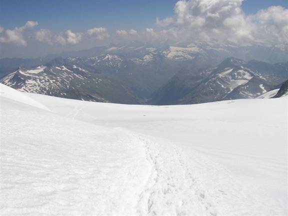
The
view opens up to the North all the way down more than 2,000 m (6,600 ft) to the
valley in the ‘Pinzgau’. The first ridges you see as highest points in the very
morning at the beginning of the valley now fall away in the distance and give
way to higher ridges and summits all around. Shortly after this stop I can see
one of the key parts of this ascent, the ‘Venediger-Scharte’ at 3,400m (11,200
ft).

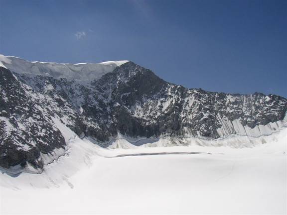
This
flank is moderatly steep and usually requires crampons. It also has a large
crevasse near the top which can be tricky to cross. As can be seen from the
pictures, conditions were optimal and you could just walk up in the steps
without crampons. Just when reaching the big crevasse I cross yet another party
and ask them to take a picture of me with the crevasse and summit in the
background.
I
remember this part from many years ago where we negotiated an icy flank, on skis,
roped up with a friend, much worse visibility, making this part more tricky.
This part also reminds me of the climb up
As
soon as I reach the saddle between the small and the big peaks (
‘Kleinvenediger’ and ‘Grossvenediger‘) just after 11:00am, I can see towards
the South. There are some harmless cumulus clouds framing the view to the

Hard
to believe that we reached this peak with our hanggliders in August 1995,
almost exactly 10 years ago! But that’s a different story…
The
view also opens up towards the East down towards the ‘Prager Huette’ and the
valley called ‘Innergschloess’ which features a shorter ascent to the
Grossvenediger, albeit with more crevasses and thus considerably more dangerous
when climbing solo.
On
this last stretch I feel like adding the Turbo to my engine. While I still feel
moving strongly the effects of altitude above 3,500 m start to kick in. After
all, I am now more than 10,000 ft higher than
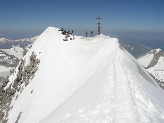
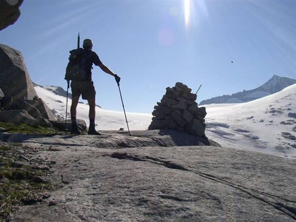
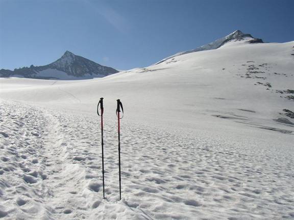
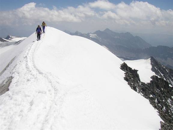
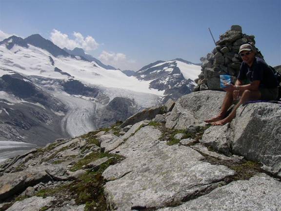
There
is one more section which requires caution as can be seen in the first picture
of this report. It’s good to have ski poles when following the narrow and
somewhat exposed ridge.
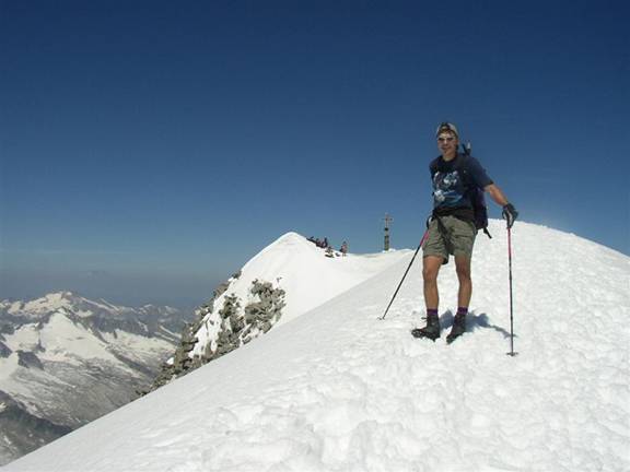
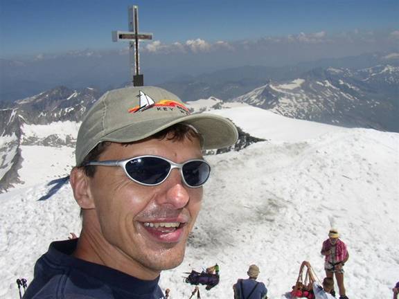
The
view from the top is stunning. I take 10 individual photos which I will later
stitch together to form one great panoramic picture. (See here for this and other
panoramic views.) From this selection, here is the view towards the West along
the ‘Alpenhauptkamm’.
The
summit is all the more sweet due to the mild temperatures and relatively calm
winds, which allow me to sit in shorts and T-shirt at the summit at 3,674 m
(just above 12,000 ft). In fact, I will not wear anything else other than this
except during the evening swim in a small bathing lake in Stuhlfelden. All the
extra gear carried but not used – well, just like the seat belt in the car or
any other protective equipment, you hope you never have to use it, but you
can’t go without it.
As
I take the following picture from the top of a snow cone about 10 ft higher
than the cross, there is no one standing higher than this (except on the
Grossglockner) to the East anywhere in the Alps and about 100 km (60 mi) to the
West. In case you didn’t notice, this is how I look when I’m thrilled.
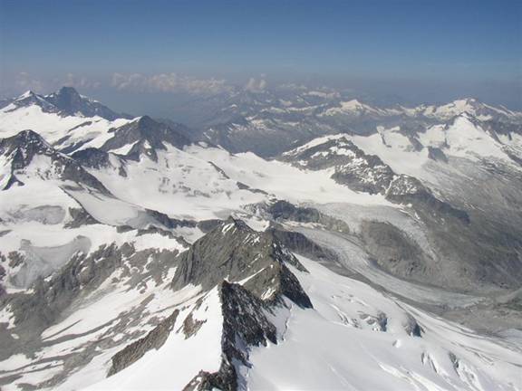
One
more picture shows the great dimensions of this mountain and the different
climate zones you cross when ascending from the bottom to the top. Notice the
shadow of the summit cross in the foreground and the massive glacial cover of
the top flank of the mountain. The view reaches down more than 2,000 m (6,600
ft) to the South entrance of the Felbertauern-Tunnel, one of the main arteries
for North-South traffic across the

As
spectacular as the view is from the summit, after more than 1 hour I have to
turn away and start going down. A long descent awaits you from the top.
Thankfully, the softening snow makes for a much faster descent due to sliding
with every step. Due to this sliding and the fact that I am moving solo and not
roped up with climbing partners I descend much faster than another party
starting at roughly the same time. I take the next picture after descending
roughly 350 m (1,000 ft) in only 20 minutes. From this spot it took me more
than 1 hour to reach the top going up. (On soft snow you can easily descend 3
times faster than ascending, while on rocky ground it’s hard to be 2 times
faster.)
The
sun is beating down relentless and walking on the snow is uncomfortably hot.
After 5 hours on the glacier I am glad to get back down on the rocky slopes
above the Kuersinger hut. I take my boots off, apply more sunscreen, drink and
eat some cookies.
I
wish I could just sit here for hours and enjoy the view, the food and the fresh
air. The simple joys of a great day in the
The
path leading down looks slightly different going down and with the afternoon
sun. There are more people here hiking just to the hut. I ask someone for
another picture. Perhaps taking so many pictures is my way to compensate for
the lack of a hiking partner? In any case, the memory capacity of the digital
camera makes it possible to just take many pictures and then select the best.
Today it just seems as if most or all of the pictures turn out great.
My
feet are getting tired and a blister isn’t far away on my right ankle, despite
band-aids and a fresh pair of socks. I am very happy when I am back down at my
bike around 4:30pm – some 12 hours after starting this trip. From now on I
don’t need to walk anymore, just roll downhill from here. How sweet is this!
I
need to be careful due to the varying road surface, the at times steep road and
my generally tired condition. I also forgot my bike helmet last night when
packing, so I have even less protection than usual.
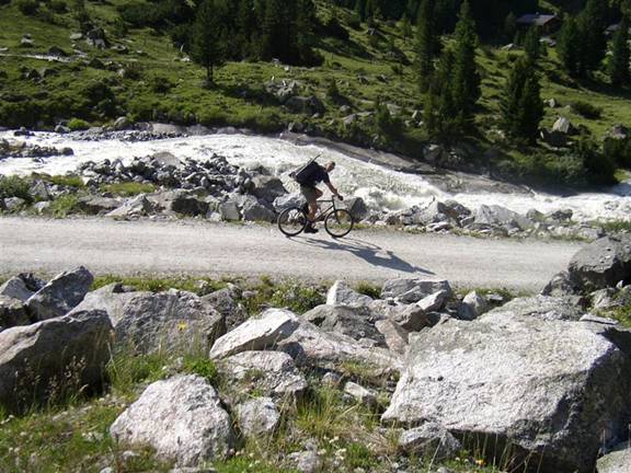
A
switchback in the road with some people hiking down just there marks another
good spot to have a picture taken against the torrent of the stream draining
all the melting water off the glaciers above.
The
air is getting hotter and my mood is getting higher as I descend fast. Within
minutes I reach the Postalm and Berndlalm in inverse order of the ride up in
the early morning hours. At the Berndlalm I stop for a last snack. The location
and surroundings make this a real treat. In addition to the coffee I eat
‘Kaiserschmarrn’, a sweet delicacy made of eggs and flour with lots of sugar
and marmelade. Like high octane fuel for a high performance motor …
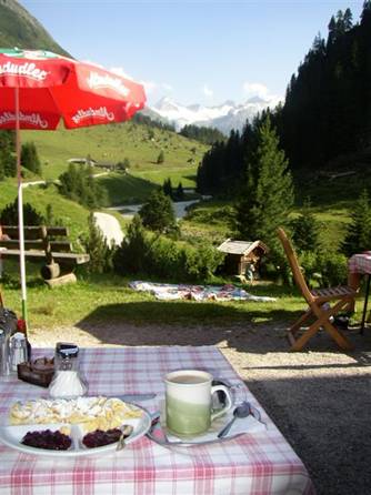
This
picture embodies so much of the Austrian way of life: Great food, alpine
setting with meadows, cows, mountain streams, high snow-capped peaks, blue
skies - just wonderful. Another post card worthy Kodak moment of this long day.
Another
10 minutes after leaving this heavenly place I reach the car at the parking
ground near the very bottom of the mountain at 5:45pm. Changing boots and
loading the disassembled MTB into the trunk I start the long drive back. One
short stop for a swim in a beautiful lake not only rounds out this great day,
but also cools me off sufficiently for the next hour or so in the car. At
8:00pm I am back in
I
was really lucky with the weather turning out so great on the second to last
day of my vacation. It was the hottest day of the year, with up to 37 C (100 F)
in parts of